Date: 2 July 2025
Authors: Assoc. Prof. Dr. Kadir Alperen Coskuner and Dr. Georgios Papavasileiou ; WG4 – European Network on Extreme Fire Behavior (NERO)
Summary:
On 29 June 2025, two major wildfires broke out near Orhanlı village in the Seferihisar district of İzmir Province, Türkiye. Intense heat, prolonged drought, and strong winds fueled rapid fire spread across forests and shrublands.
The first fire (Fire A) ignited at 09:57 UTC and advanced nearly 12.8 km in under 3 hours, with a spread rate of ~4.8 km/h. A second fire (Fire B) ignited about 10 km west of Fire A and spread southwest. Both fires were driven by strong northeasterly winds gusting up to 80 km/h.
Key Facts:
- Event: İzmir, Orhanlı Wildfires (Fire A & Fire B)
- Date: 29 June 2025
- Location: Orhanlı, Seferihisar district, İzmir Province, Türkiye
- Coordinates: Lat: 38.191543°, Long: 26.990643°
- Area Burned (as of 30 June 2025):
- Fire A: ~4,278 ha
- Fire B: ~3,542 ha
- Total: ~7,819 ha
- Fuels: Pine forests, shrublands (maquis), grass
- Type: Surface and crown fire
- Observed Behavior: High spread rate, spotting
- Weather: Wind-driven, low moisture, sustained winds ~50 km/h, gusts up to 80 km/h
Impacts:
- Fires spread into Menderes district
- Evacuation of ~7 villages
- Homes and vehicles destroyed
- Challenging suppression due to extreme wind and dry conditions
More Info:
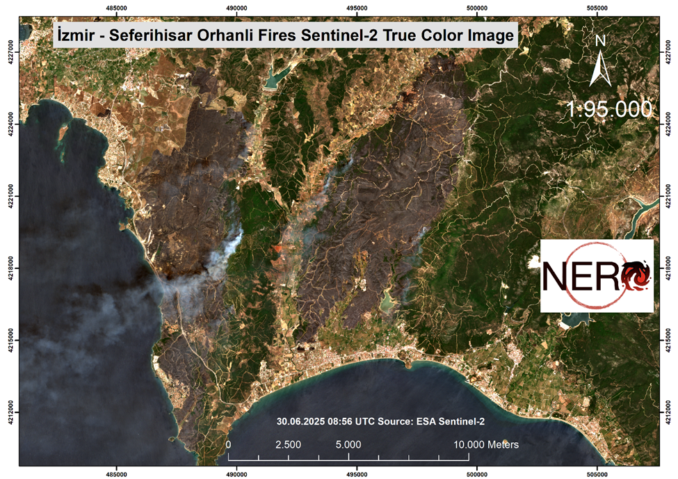
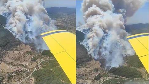
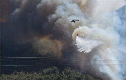
Figure 2. Convection column of the ongoing fire (a, b) (29.10.2025). Source: DHA
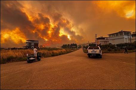
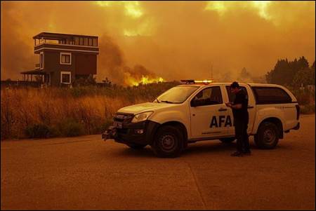
Figure 3. Images from ongoing fire (a, b) (29.10.2025). Source: AA, DHA
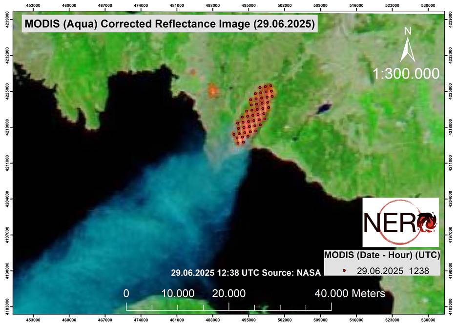
Figure 4. The combination of the MODIS (Aqua) Corrected Reflectance image (Bands 7-2-1) and MODIS thermal anomalies for this fire (29.06.2025 12:38 UTC). Source: NASA
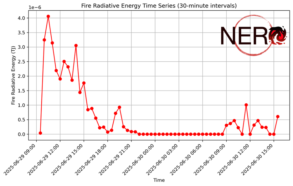
Figure 5. Fire Radiative Energy diagram of the Orhanlı fires (Time-UTC), (Note: The fires were ongoing between June 29 at 21:00 and June 30 at 09:00; however, the sensor did not detect any radiative energy, likely due to cloud cover over the fire area) Source: EUMETSAT
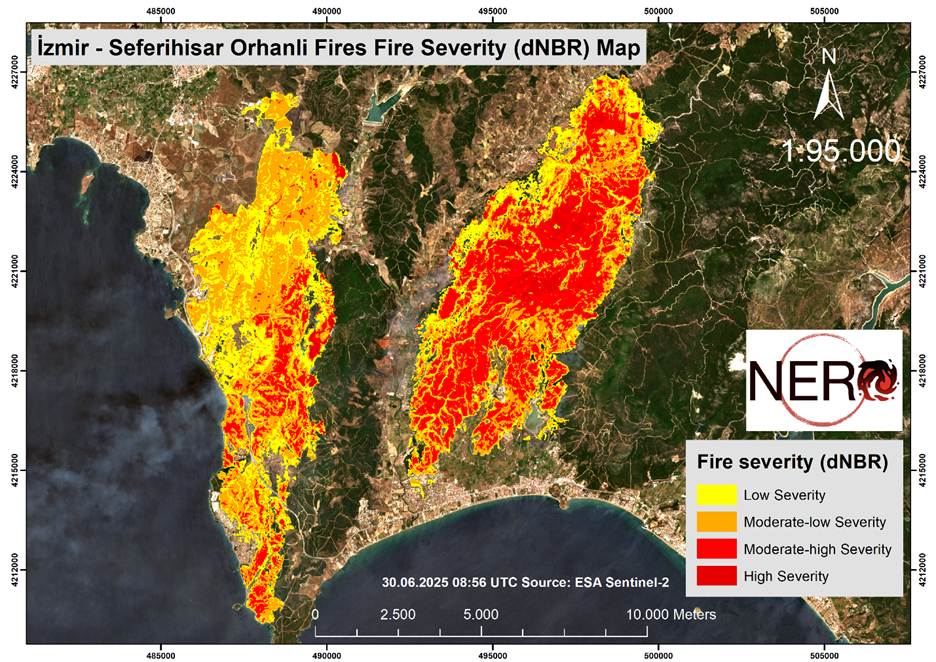
Figure 6. The results of initial differenced (or delta) Normalized Burn Ratio (dNBR) analysis of fires using Sentinel-2 images, captured on 30 June 2025 at 08:56 UTC. Source: ESA – Sentinel-2.
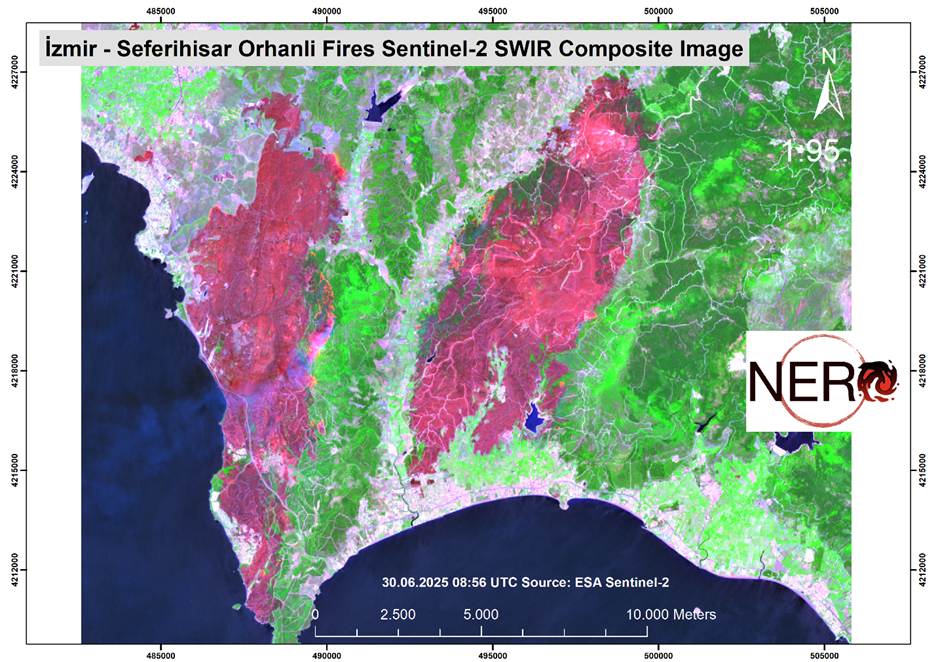
Figure 7. Sentinel-2 Shortwave Infrared (SWIR) composite images of the ongoing fire, captured on 30 June 2025 at 08:56 UTC. This satellite composite image reveal thermal characteristics of the fire, offering critical insights into its early spread and intensity. Active parts are visible. Source: ESA – Sentinel-2.
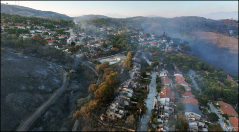
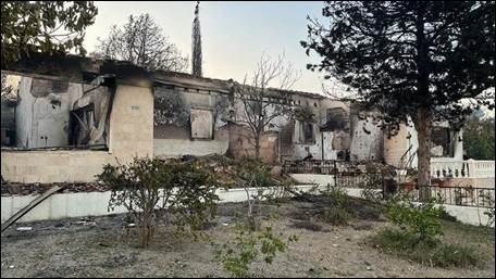
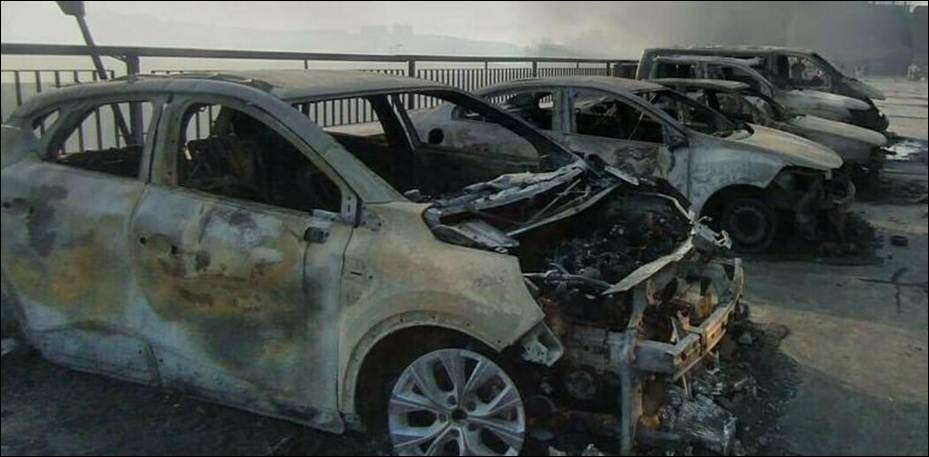
Figure 8. Fire-damaged houses (a, b) and vehicles (c) (29.10.2025) Source: HABERLER, CNNTURK, DHA
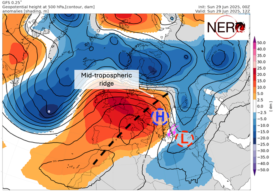
Figure 9. Synoptic fire weather conditions on 29 June based on short-term forecast data from NCEP/GFS.
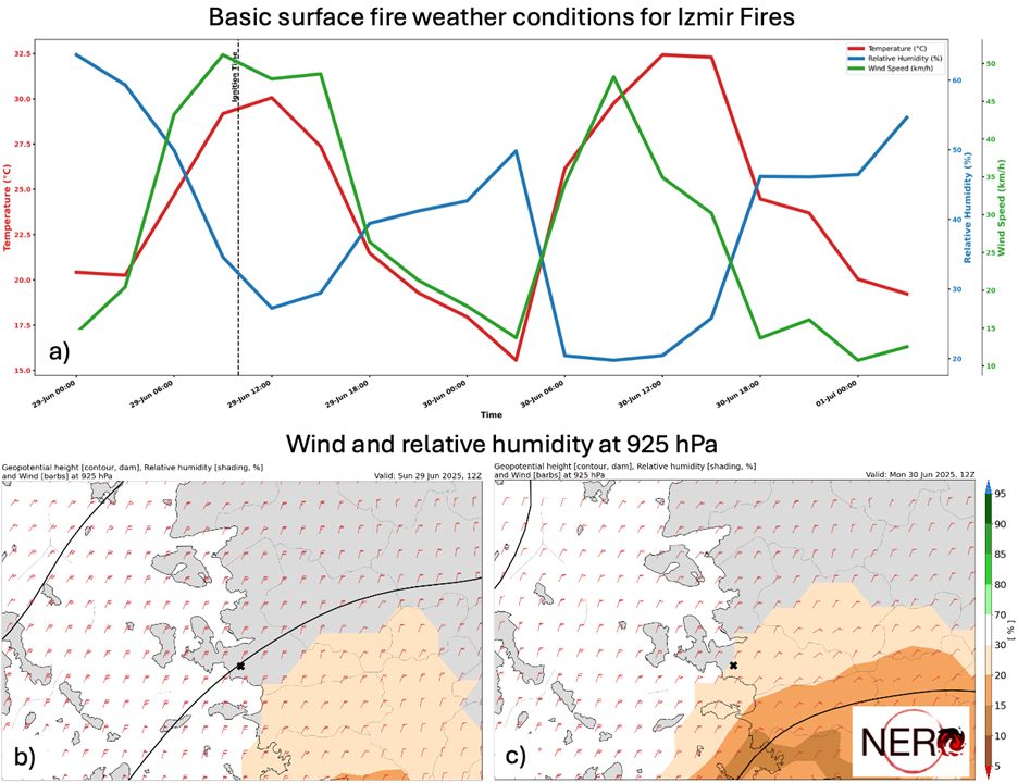
Figure 10. Mesoscale fire weather conditions in the broader area of Izmir fire on 29 and 30 June based on short-term a) surface temperature, wind and relative humidity WRF forecast data (at 2km horizontal resolution) from the FLAME – Fire Meteorology Group of the National Observatory of Athens, b) and c) 925 hPa wind and relative humidity NCEP/GFS forecast data.