🖊️ Prepared by: Dr. George Papavasileiou (papavasileiou@noa.gr), National Observatory of Athens, Greece (🇬🇷)
Wildfires ignited in the Anpyeong-myeon area of southeastern South Korea between 21 and 22 March 2025. On 25 March, these fires exhibited extreme behavior, including rapid spread and the development of a pyrocumulonimbus (PyroCb) cloud — potentially the first satellite-documented pyroconvective wildfire in South Korean history. By 27 March, tens of thousands of hectares had burned, with multiple fatalities reported in national media.
Exceptionally Rapid Fire Spread
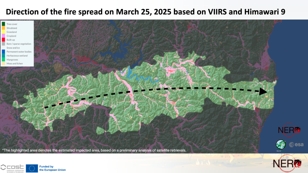
On 25 March, fire fronts advanced rapidly toward South Korea’s east coast, with a mean rate of spread (ROS) of approximately 7.1 km/h. The fire covered more than 50 km in less than seven hours (Figure 1; see also video above).
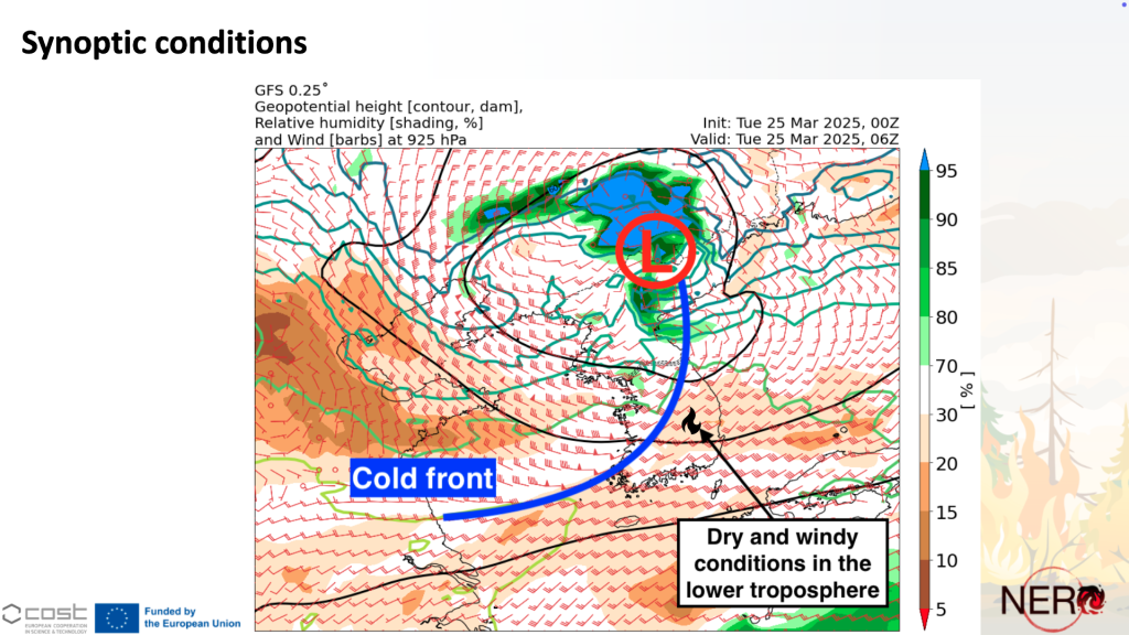
The rapid spread was primarily driven by strong westerly winds linked to the passage of a cold front over the Korean Peninsula (Figure 2), with surface wind speeds exceeding 50 km/h, according to Korean Meteorological Administration (KMA) observations. Very dry atmospheric conditions — with vapour pressure deficit (VPD) values above 2.8 kPa — further contributed to the intensification of fire behavior.
The affected landscape features complex topography, with hills and valleys ranging from 100 to 800 meters in elevation (Figure 1). Hillslopes are predominantly forested with Korean red pine and mixed deciduous species, while valleys are mainly cultivated croplands — a land cover pattern that may have influenced fire spread variability across the terrain.
🏜️ Antecedent Dry and Warm Conditions
In the days preceding the event, the region experienced unusually high temperatures exceeding 25°C — more than 10°C above climatological norms for this time of year. These anomalous conditions likely contributed to elevated fuel flammability across forested areas.
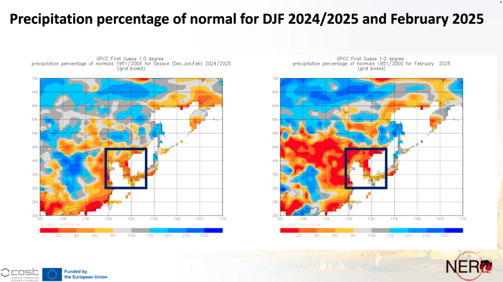
A pronounced precipitation deficit was observed throughout the winter and early spring. Cumulative precipitation between December and February reached only 20–40% of normal levels, with February alone receiving less than 20% of average rainfall. These conditions likely resulted in critically dry fuel beds, contributing to increased fire intensity (Figure 3).
💨🔥☁️ Fire–Atmosphere Coupling and PyroCb Formation
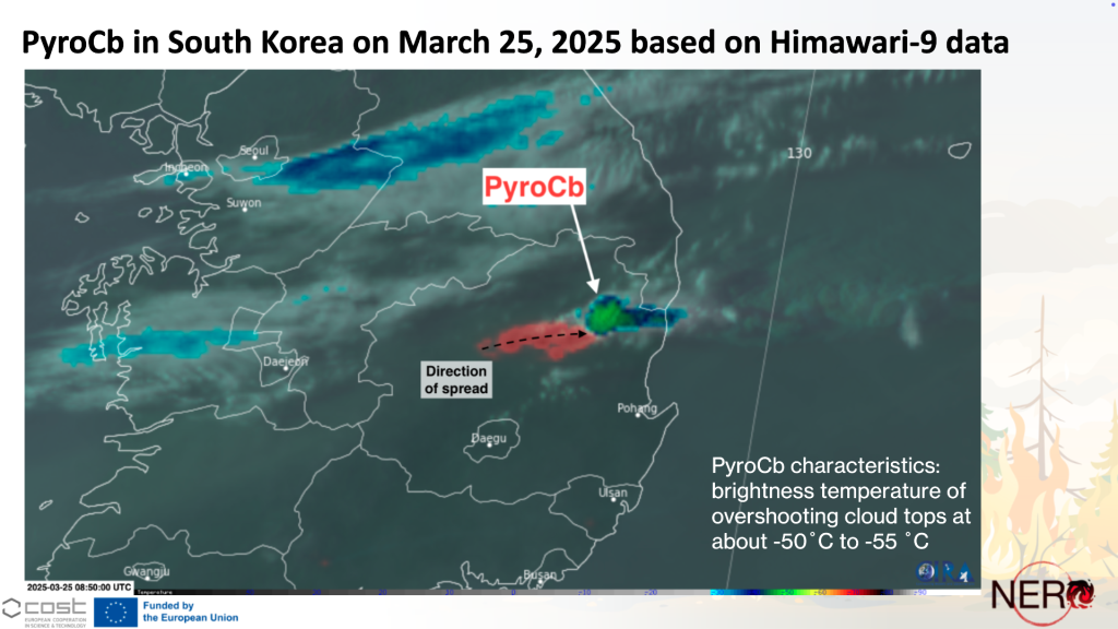
During the afternoon and evening of 25 March, the wildfire transitioned from a wind-driven phase to a plume-dominated regime, producing a pyrocumulonimbus (PyroCb) cloud with overshooting top brightness temperatures ranging from –50°C to –55°C (Figure 4). This transition marked a significant intensification of fire–atmosphere interactions, with potential implications for both fire behavior and local atmospheric dynamics.
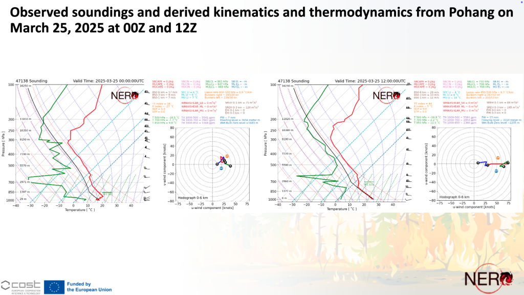
Despite atmospheric conditions that were not conducive to pyroconvection — including strong deep-layer shear and a mid-tropospheric inversion (Figure 5) — the fire’s extreme intensity, or other contributing factors discussed below, likely enabled the development of a deep convective plume.
PyroCb events can further intensify wildfire behavior by generating localized strong winds, downdrafts, and, in some cases, dry lightning — all of which may influence fire spread and complicate firefighting operations.
🔬 Key Research Questions for Further Analysis
This event raises several scientific questions that warrant further investigation, particularly regarding fire–atmosphere interactions, topographic influences, and plume dynamics:
- Topography–Wind–Fire Interactions: Did terrain-induced wind patterns — such as hydraulic jumps or lee effects — contribute to turbulent fire spread or enhance fire–atmosphere coupling?
- Dust Concentrations and Radiative Effects: Could elevated dust levels observed on 25 March have influenced atmospheric stability or plume buoyancy through radiative feedback mechanisms?
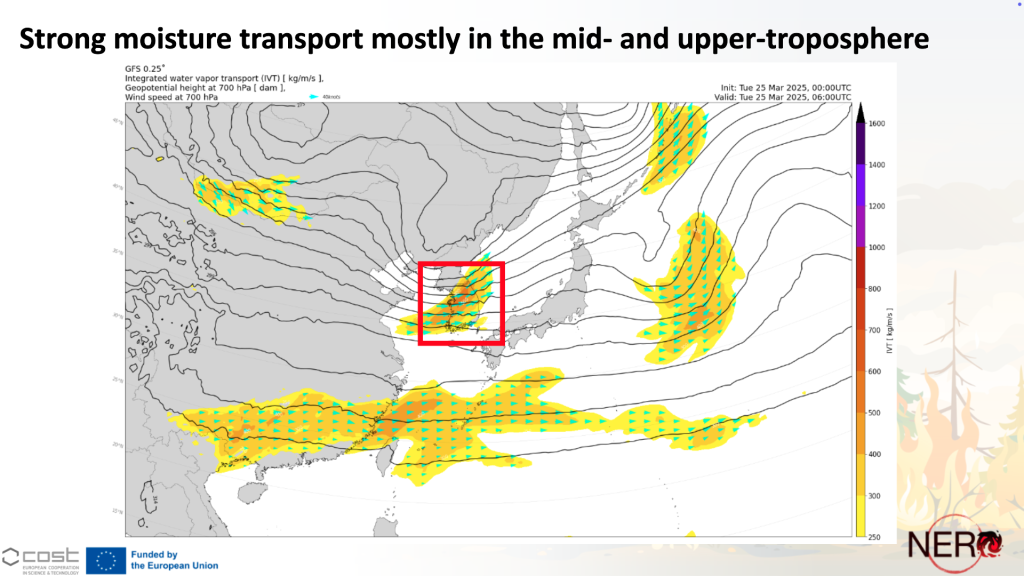
- Mid-Tropospheric Moisture Transport:
What role did the short-wave trough and associated moisture advection in the mid- and upper troposphere (Figure 6) play in enabling deep convective plume development? - Fire Intensity Thresholds for Plume Transitions:
To what extent did the fire’s heat release and spatial extent contribute to its transition from a wind-driven to a plume-dominated regime?
These questions are central to advancing our understanding of pyroconvection dynamics in non-traditional regions, such as East Asia, and improving predictive capacity for similar high-impact events globally.
⚠️ Implications for Wildfire Science and Risk Management
This event underscores the need to:
- Enhance fire weather forecasting and early warning systems, particularly in the context of increasing climate variability.
- Consider wind-driven fire spread risk even in regions without a historical record of large-scale wildfires.
- Recognize the growing potential for pyroconvection in non-traditional wildfire regions, including parts of Europe and Asia, where such phenomena have historically been rare.
The NERO Network will continue to monitor this case and welcomes collaboration to better understand the mechanisms underlying its exceptional behavior.
